
Welcome to archived PADES Watch reports:
"Precisely Appropriate Decisions
for Ecological Sustainability"
A citizen's resource for information about local habitat, river restoration, and conservation matters in the Town of Kennebunk.
Check in frequently for updates and news.
What's happening around town that affects our environment, our quality of life, wildlife habitat and pollution?
Comments? Reports? Photos? E-mail to <ai2q (at) ai2q.org>
![]()
REPORT (30 January 2015):
You may recall that the Town screwed up royally when the Kennebunk Public Works Department bulldozed a vital coastal frontal dune last Autumn (see October 18th 2014 and December 16th 2014 REPORTs, below) on Great Hill Road. Apparently the Public Works folks were trying to create a "snow storage" area.
Well, "to err is human; to forgive divine," as the old saying goes.
According to a report that appeared in the York County Coast Star newspaper (Jan. 29th issue) Kennebunk just bellied up to the proverbial bar to the tune of $3,450-plus. The $3,450 is the fine the Maine Department of Environmental Protection levied on us taxpayers.
But wait!

There's more! Kennebunk also had to dish up roughly another $2,200 for "replacement materials," and about $3,600 for labor, in order to remediate the mess.
Add it all up and you're looking at a cost of a whopping $9,300.
Wasted tax money aside, what will this piece of coastal land look like after the erosion control measures have been applied, and the symmetrical plantings take root?
If the snow ever melts we may get a look this coming summer.
REPORT (8 January 2015):
Climate change. Global warming. Energy security. Military security.
Real or imagined?

Spend 53 minutes watching this National Science Foundation documentary and decide for yourself.
https://www.youtube.com/watch?v=2RyvpsIx47E&feature=player_embedded
REPORT (5 January 2015):
Happy New Year!

Looking over the Town's SEDAP (plan), here's an admittedly unscientific analysis:
The word "business" appears 28 times, excluding page headlines.
The word "economic" or "economy" occurs 26 times.
That would be expected in an economic development plan, right?
But, what about sustainability?
If human ecology has anything to do with economics, a polluted and decaying environment is not going to help the economy in the long run.
Continuing the word-play analysis of the SEDAP document, the word "ecology" never appears.
The word "habitat" never appears.
The word "nature" appears five times.
The word "water" appears six times.
The word "river" appears eight times.
The word "energy" appears once.
The word "solar" never appears.
The word "alternative" appears twice.
The word "Mousam," as in the beautiful, perhaps someday bountiful, Mousam River, appears three times.
You do the math.

REPORT (30 December 2014):
What? Again? More bulldozers in our wetlands?
Yes. They’re at it again. Look out! The Harrington machine is rolling!

Not content with the imminent destruction of treasured wetlands at the so-called “Cottages at The Salt Marsh” development (please review the 22-October PADES REPORT, below) the eco-marauders at Seagrass LLC are now eyeing another tract, this one comprising no less than 30 acres on Kennebunk’s sensitive Lake Brook stream.
The site is replete with Priority One wetlands and the town’s Resource Protection Zone. Remember, too, these are the "crown jewels" of Kennebunk's natural resources.
Viable Valuable Limited Liabilities
Apparently it pays to have as many LLCs (limited liability corporations) as you can muster as you attack Lake Brook.
If you were to examine the preliminary map for the 30-acre destruction site along Lake Brook, you’d see the Seagrass LLC moniker in the drawing’s lower right-hand corner. WTF?
But, this time the ecology-mad folks at Seagrass are using the name Seaport Development Group in its bid for land at Lake Brook. If you split up your attack with as many LLC organizations as your attorneys can craft, can you get away with truly limiting your liability if and when the manure hits the ventilator?

Unfortunately for the critters that make up the ancient wetlands habitat there, the proposed construction site of 24 house lots needs only a meager 25-foot setback from the stream. Why? Because the land is within the Town of Kennebunk’s Lower Village Business (LVB) zone. So, the normal 100-ft setback, which is still pitiful, is only a measly 25 feet, much to Seaport Development Group’s apparent delight.
At a recent meeting of Kennebunk’s Planning Board at Town Hall, one esteemed member of the Board exclaimed, “You’re closing in on Lake Brook! We’re running out of developable land and now you’re eying our wetlands.”
The “plan,” which greedy Seaport developer Mike Spenlinhauer calls “less horrific than other development that will occur if mine isn’t adopted,” calls for two stream crossings (great non-point-source pollution points), and filling in about 11,000 square feet of wetlands. By the way, that “less horrific” comment elicited a comment from an abutter feeling threatened by that verbiage!
The Seagrass LLC contract zone for “The Cottages” development on Western Avenue (see the 22-October PADES REPORT, below) already blasted 15,000 square feet of wetlands, and here’s another 11,000 square feet in the offing.
Where will this wetlands destruction madness end? Mike Spenlinhauer wants to call his project The Morning Walk. Cute, eh? Perhaps Mr. Spenlinhauer should take a walk.
Stay tuned for further details.
REPORT (21 December 2014):
Power company Kennebunk Light and Power's newly retained consultant (refer to the 19 November REPORT, below) is trying to help its director and board of trustees deal with the problems of its three ancient hydroelectric dams on the Mousam River.
Now's the time for the company and the town to evaluate socio-economic impacts on Kennebunk's community, eh?
Eliminating the pond-like waters backed up behind each dam (they're technically called impoundments) will most certainly improve the river's once beautiful aesthetics.
What else can that translate into?
For starters, here are three scenarios:
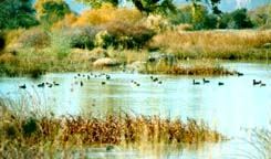
(1) If the dams are removed the Mousam will become a free-flowing river again. Folks will enjoy natural rapids, small waterfalls, and large natural pools--just like early settlers saw.
Fact: at other dam removal sites in Maine there has been rapid natural re-growth of vegetation.
Keep in mind that re-vegetated areas along the river greatly enhance habitat. Newly invigorated migration corridors form. These support a diversity of birds and other riverine species.
Think economics!
(2) Removing KL&PD's worn out dams will provide new opportunities for public access.
You can bet that more fishermen, bird watchers, artists, photographers, hikers, and paddlers will boost the income of recreation-dependent businesses in town.
Can you envision a boom in canoe and kayak rentals? How about bait and tackle shops? Hhmmm.
Then there are the myriad restaurants, hotels, motels, food stores, gift shops, and service stations that eco-tourists use. Sounds like a good SEDAP deal, eh?

Bait!
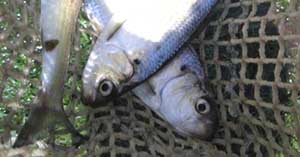
(3) Restoring the Mousam River's ecosystem will also boost the availability of bait for fishermen, and especially lobstermen.
Indeed, The Lobster Institute estimates that lobstermen require up to 800 million pounds of herring annually to bait their traps.
That much bait and its cost is now a major problem.
Restoring local sustainable populations of river herring can address this shortage.

Did you know The Maine Lobstermen’s Association has been tracking the increase in bait prices over the last several years?
Its figures show big jumps in bait prices.

Maine fishermen used to springing for 30 cents to bait a trap now find it costs a dollar or two per trap. The paltry supply of bait at a reasonable cost plagues the Gulf of Maine lobster fishery.
Restoring the Mousam River watershed and habitat, by getting rid of those pesky dams, will most certainly alleviate that pain.
It's all inter-related!
REPORT (16 December 2014):
Well, it looks like Kennebunk's Department of Public Works engaged in a bit of remediation!
If you recall (you can scroll down to the 18 October 2014 REPORT), the department seriously screwed up prepping Great Hill Road for some next phase of road "improvement." The narrow neck of Great Hill Road between the ocean and the marsh, in the Shoreland Protection Zone, was totally trashed.
It has now been "restored."
Here's a before and after photo for your edification and amusement.
Note the geometrical rows of pretty plantings. Oh so very natural looking, eh?

BEFORE

AFTER
How much did this cost the taxpayers?
How long will it take before the ground cover is stabilized?
What will it ultimately look like? Is this what a "wetland restoration" might look like as well?
REPORT (9 December 2014), The Shell Game:
Ocean acidification from greenhouse gases? Here in Maine?
You may recall the PADES report (22 October, below) about the proliferation of jellyfish in Libby's Cove. Well, it may get worse.
A Maine assessment commission is now looking into the effects of ocean acidification on lobsters, clams, and other shellfish.

The Maine legislature seems to be waking up to global warming. Indeed, it created the special assessment commission in response to the hard core scientific discovery that atmospheric carbon dioxide levels are causing Maine's waters to become acidic---30% more acidic, matter of fact----as they absorb greenhouses gases.
Any critter's body that forms a shell, and that includes everything from lobster to shrimp, as well as plankton, may suffer. They won't be able to naturally produce calcium carbonate to make their shells.
The report indicates acidification will likely intensify as Earth's climate warms. Details in a Portland Press Herald report here.
REPORT (29 November 2014):
More Factoid Food For Thought

The beautiful Mousam River, and its diverse habitat, deserve thorough restoration. The three November 20th PADES "factoids" (read 'em below) revealed a number of salient facts about the river.
Here are a few more factoids food for thought.
Factoid 4: There's little doubt that hydropower makes a minimal contribution to Kennebunk Light and Power District's current revenues. The dams exert little influence on the rates it charges customers.
Even if KL&PD's current hydropower output were to double---or even triple---from 2012 levels, the savings generated would still remain negligible to the average ratepayer.
Factoid 5: The Federal Energy Regulatory Commission (FERC) will require many studies that will impact KL&PD's relicensing decisions.
These studies must assess the dam’s impact on water quality, hydrology, geology, and fish. The studies must also assess aquatic species, plants, and plant communities.
Wildlife, recreation, aesthetics, and cultural resources must also be studied. We're talking "Big Bux" here.
Madison Electric Works of Madison, Maine estimated that its cost for relicensing----for its single dam on the Sandy River----would come in at nearly half a million dollars.
Wisely, the folks at Madison Electric Works chose not to proceed with FERC relicensing. They removed the Sandy River dam.
Factoid 6: Then there's the Federal Power Act. FERC's legal authority comes from the Federal Power Act.
Even if FERC grants the power company a new ticket, both upstream and downstream fish passage requirements will be required as part of the new license. That's a requirement that will cost KL&PD dearly.
The costs for a fishway can range from several hundred thousand dollars to many millions of dollars. It all depends on the targeted species of fish that need to be passed. Remember, KL&PD owns three of these impediments. It would need to provide safe, timely, and effective fish passage facilities at each of the three dams. Read: $$$$$$$
Factoid 7: The KL&PD folks would need to assess, in a methodologically sound manner, the effectiveness of both upstream and downstream fish passage at each dam.
These costly evaluations would have to focus on the sea-run fish species found in the Mousam, including American eel, American shad, alewives, and blueback herring.
Suppose these evaluations don't make the grade? Well, failure to prove the efficacy of fish passage for all affected species could result in mandated additional remedial operating expenditures or more capital spending.
How much? It's anyone's guess, but you can bet it ain't gonna be cheap, recognizing that fish passage is more than just a one-time capital expenditure. Fish passage imposes continuing monitoring costs as well as perpetual operations and maintenance expenses.
Uncooperative Critters

American shad
KL&PD may face a particular challenge in achieving fishway effectiveness, as American shad are notoriously reluctant to pass through most conventional fishway structures.
REPORT (22 November 2014):
Two years in the making, the Town of Kennebunk's economic development consultant is getting ready to release his SEDAP document, outlining ways to spur economic development in town.
But, whoa!
Whatever happended to the previously released "plan" and report, issued to the town in 2009 by consulting firm Crane Associates, Inc.?

Crane report, cover
Billed as a roadmap for a "sustainable economy" embracing "natural ecosystems," has the Crane report been disregarded by the Town of Kennebunk? Is that how taxpayer monies are spent, nay, squandered?
No less than 15 pages in the Crane document are devoted to what's dubbed a Strategic Industries Analysis, summarizing a whopping 63 spreadsheets about employers, wages, job trends, business-to-business plans, and the importation and exportation of dollars in and out of the Kennebunk economy.
Sound familiar?
Has this report been abandonded? Disregarded? Trashed? Discredited? Replicated at taxpayer expense in the SEDAP?
You can download a copy of the plan by clicking here (right click to save). It's a 4.7 Mbyte Adobe Acrobat .pdf file.
You be the judge.
REPORT (20 November 2014):
So, what is the real, or perhaps imagined, effect of hydropower on Kennebunk Light and Power District's (KL&PD) financial health and customer rates?

First off, keep in mind that KL&PD is essentially a broker of electricity. That is, it buys electricity from other producers, and then it sells that power to the customers---you and me.
While hydropower is indeed a "renewable resource," it has significant negative environmental impacts. Let's look at a few facts:
Factoid 1: In 2012, hydroelectricity generation from KL&PD's three Mousam River dams constituted approximately a measly 1% of the company's total electricity supply.
The other 99 percent was purchased from outside sources via the regional electricity supply network. During the period of 2005 through 2012, hydropower generation from KL&PD’s three dams has varied from year to year but, on average, has accounted for just 1.6% of KL&PD’s annual energy supply needs.
Factoid 2: In 2012, net revenue from the dams (its sales less its operating costs) was approximately $52,000.
This figure actually overstates hydro savings because KL&PD doesn't allocate in its Annual Report any administrative or other overhead expense to hydro generation. To make the point, KLPD has spent considerable staff time and consultant fees for dam-related matters.
Factoid 3: Hydropower generation reduced the typical Kennebunk household’s cost by about 35 cents a month. Wowee, huh?
Only 45% of KL&PD’s 2012 revenue from electricity sales came from its approximately 5,500 residential customers (it derived the remainder from industrial, commercial, and governmental customers.)
If you assume that 45% of the (overstated) $52,000/year cost savings went to these customers, the typical household in Kennebunk received hydro-related savings of about $4.18, or an average of 35 cents a month.
This is about one half of one percent of average 2012 household electricity costs ($902).
Hoop-de-doo! 35-cents a month to screw up riverine habitat.
REPORT (19 November 2014):
Flash! Kennebunk Light and Power District (KL&PD) rolled out an elaborate timeline at last night's Board of Trustees meeting. The timeline includes milestones through December 2015.

The company's newly hired Project Manager Pat McIlvaine described a detailed process involving Federal and state agencies, as well as a series of public outreach meetings and analyses. Dam removal is certainly front and center for KL&PD's Board of Trustees.
Stay tuned for more details.
REPORT (18 November 2014):
Kennebunk Light and Power District (KL&PD), also known as the "Kennebunk power company," says it wants to engage the public in a conversation about the future of its three dams on the Mousam River. It wants to do this before deciding whether to pursue a new license from the Federal Energy Regulatory Commission (FERC).
What's that?
The company had one public meeting last year---and that was it. Not much of a conversation...
$$$$$
Keep in mind that hydropower dam relicensing is a complex and very expensive process. It will demand significant financial resources from KL&PD.

Dane Perkins dam on the Mousam R.
Is it a stretch of the imagination to conclude that dam removal will provide more benefits---environmental, economic, social, and recreational, for more people----than keeping the dams?
Factoid 1: Pursuing relicensing could run several million dollars by the end of the process. Even with that tremendous investment, there's no guarantee FERC will grant new licenses to KL&PD.
Factoid 2: If the KL&PD dams were to be relicensed, there would be some astronomically high costs involved to construct and maintain upstream and downstream fish ladders at all three dams. Those fish passages will be mandatory if the dams are relicensed. But, there's a big question whether such ladders will suffice for all species.
Finally, keep in mind there are more than 40 major river systems in Maine, but the Mousam River is now the only one remaining that completely lacks fish passage. Yow!
REPORT (11 November 2014):
The Kennebunk Light and Power District, also known as the "Kennebunk power company," sent along a bit of a newsletter along with its latest billing notices. KL&PD has a new project manager, apparently hired to move along the process of trying to figure out what to do with its three aging hydroelectric dams on the Mousam River.
Here's an extract from the latest newsletter:
So, what's conspicuous by its absence?
Well, there's no mention whatsoever of habitat, ecology, water quality, fish runs, fishing, alewives, elver harvests, eagle sightings, or sharply declining cod stocks.
Indeed, the KL&PD "report" is entirely devoid of any essence of responsibility about the interlocked relationships of the natural world---including humans!
The ol' Mousam is heavily impacted by the three Kennebunk Light and Power District dams, as well as several other dams throughout the river watershed.
What's more, the Mousam is the only major river in Maine completely lacking in fish passage. Pity those poor fish trying to return to their spawning grounds, only to be thwarted by impassable manmade obstructions.
You can learn more about the Mousam River at the Mousam and Kennebunk Rivers Alliance Web site.
REPORT (3 November 2014):
Been down to Gooches Beach lately? Have you noticed how the FEMA-built seawall has deteriorated---way before its time?
Many of the huge 12-in. square pressure treated timbers, some as long as 8-ft. in length, have disappeared!
Some of the timbers litter the beach, but the town tries to clean 'em up, perhaps before anyone really notices. Others float out to sea. Some have been plucked by local opportunists in pickup trucks.
In the section of sea wall you see here, fully 2/3rds of the timbers, and their associated mounting hardware, have been ripped away by time and tide. Now, mind you, this protective seawall is only a few years old.
Did FEMA do a good job designing this?
Did FEMA spend our tax dollars wisely?

The iron plates behind the timbers are also disintegrating. Many of the large threaded bolts and nuts are also either loose or missing.

Whether you wish to accept it or not, the sea is rising. Just ask the folks at Wells Reserve, and check out the photos there.
This photo is at Gooches Beach in Kennebunk during a low tide storm.

Last year, the Town of Kennebunk's Board of Selectmen were presented with a variety of sea level policy scenarios, given freely by a scientist from Maine's own Muskie Institute.
Have the selectment or the Town Manager reacted? Have they embraced a plan? What about SEDAP? Are we waiting for a big high tide storm?
REPORT (29 October 2014):
Stumbling Blocks
“Sounds like lawyer-ese to me” cries out a venerable member of the Kennebunk Planning Board at its October 27th 2014 meeting. Another member sighs about “stumbling blocks.”
Go to the Town Hall Streams Web site and be astounded.
Watch---if you can stomach the machinations----as the Planning Board, a Seagrass “engineer,” Seagrass’s circumspect attorney, and the Town Planner, in their inimitable town hall style, duke it out.
Seagrass Lane LLC continues its thrust to mess up a vital wetland that should never have been touched, and now it looks like it doesn’t really give much of a hoot about its obligation to build the Town of Kennebunk a sidewalk in return.

Seagrass’s proposed subdivision, part of a contract zone (see REPORT 22 OCTOBER, immediately below), is replete with highly detailed “sketch plans,” maps and drawings. According to the contract Seagrass made with the town (which you approved with your vote), it can mess up the wetlands with its habitat-destroying proposals in return for its installation of a freebie sidewalk along Western Avenue (Rt. 9).
The problem that caused the outcry “sounds like lawyer-ese to me” is that Seagrass has virtually no details about the sidewalk.
It has gobs of details about the Cottages at Salt Marsh subdivision it will build---but nary a word about the sidewalk it will owe the Town of Kennebunk according to the contract. Indeed, it doesn’t even want to talk very much about the sidewalk, preferring to wait until the subdivision plans are all neatly nailed down to its satisfaction.
Given Seagrass Lane LLC’s dismal track record, and the Town of Kennebunk’s acquiescence with respect to the non-installation of the promised boat launch at Sea Grass Lane, do you really believe Seagrass attorneys when they say “they’ll get to the sidewalk later”?
All of this is slated for a public hearing. Sounds like lawyer-ese to me.
REPORT (22 October 2014):
Just so you know: Here come the bulldozers!
Here come the bulldozers! Can you hear their roar?
The so-called "contract zone" the Board of Selectment promoted, and the sheeple voted for, is about to materialize at 83 Western Avenue (also known as Route 9, near Lower Village). This contract zone is within the town's Resource Protection District, and the Shoreline Overlay District.

Resource Protection District? Wat's dat?
Dubbed with the cutesy name "The Cottages at Salt Marsh," this Seagrass Lane LLC subdivision (here we go again! See REPORT, below, dated 16 October 2014) will irrevocably disrupt the natural habitat on Lake Brook.
This stream is the Kennebunk River tributary that ultimately flows into the ocean, with circulating currents that bring its waters to Gooch's Beach (according to a recently published Maine Geological Survey circulation study).

So, although some future residents will be advised not to use pesticides and herbicides on their lovely marsh-side gardens, what's to stop them from buying their favorite brand of glyphosate at Ace Hardware and liberally quashing those pesky dandelions?
Remember: any "disturbances" by a "developer" (what an incongrous moniker) within 75 feet of the stream requires a Maine Department of Environmental Protection Natural Resourcess Protection Act "permit by rule" prior to bulldozer activity.
Any developer activity within 25 feet of the stream requires review by MDEP, with an individual NRPA permit. What's more, impacts to the land within the shoreland overlay zone will require Kennebunk Planning Board approval.
The "crown jewels of Kennebunk's wetlands"
Interesting note: a prominent Kennebunk resident, active in the water quality testing program, stated: "When Normandeau designated the wetlands in this area, it said these were the crown jewels of Kennebunk's wetlands. Part of that comment, which is in the town's comprehensive plan, was meant for Lake Brook, and its surrounding marshes, which takes in the marsh between Rt. 9 and Gooch's creek as well as the area in back of this development ...."
Wanna bet SeaGrass Lane LLC lawyers will get their approvals from shortsighted businessmen?
Bye bye, another swath of habitat. So much for the viewshed, too. See ya, fish, frogs, salamanders, and birds. Adios.
REPORT (22 October 2014):
Been down to Libby's Cove, adjacent to Mother's Beach, recently?
If you dare to wade in you might be surprised to see scads of unwelcome gelatinous zooplankton there, a.k.a. jellyfish!

Some scientists say jellyfish are increasingly pervasive because they're suited to withstand changes in the ocean environment due to global warming.
"There's something out there called the Jelly Oceans Hypothesis," explains Nicholas Record, senior research scientist at Bigelow Laboratory for Ocean Sciences in Boothbay. "We're shifting toward an ocean that's dominated more by gelatinous species rather than things like fish. There are a variety of causes from over-fishing, to low oxygen (due to warming), to things related to pollution."
Check out the "Climate Change in the Casco Bay Watershed" report (.pdf file). Therein you'll find the somber assessment that "as greenhouse gases continue to accumulate in the atmosphere, seasonal and annual temperatures will rise in the Casco Bay watershed. .. Summer temperatures may experience the most dramatic change, up to 10 degrees F."
REPORT (21 October 2014):
Kennebunk's Department of Public Works continues its massive road revitalization work (see below, 18 October REPORT). But, this time DPW seems to have gotten the noses of some of the residents on Boothby Lane a bit out of joint.
Apparently, the recent widening and re-paving of this venerable country lane targeted some 250 year old oak trees. DPW and town engineer Chris Osterrieder wanted 'em cut down, but many of the folks living there flatly said no.
Some of the trees have indeed been "trimmed," and the new roadway, while nice and smooth and a pleasure to drive, comes right up to the tree trunks.

REPORT (18 October 2014):
Kennebunk's Department of Public Works might be getting a tad aggressive these days. Now that DPW has finished prepping the Sea Road (for who knows what?) by ripping back the turf on both sides of the road, it has turned its attention to Great Hill Road.
The narrow neck of Great Hill Road that runs between the ocean and the marsh has been severely disturbed. Does anyone pay attention to the town's Shoreland Protection zones?
Image: 16 Oct. 2014
In came the bulldozers (perhaps under dead of night?) to rip up the sides of the road, including the side that bordered the marsh.
Before the 'dozers got to this, the land was dense scrub growth. That growth comprised a decent buffer for pollutants, such as road oil, asbestos, and lawn chemicals that might try to wend their way into the marsh.
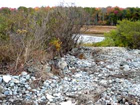 Image: 16 Oct. 2014
Well, DPW, in its definition of wisdom, bulldozed the scrub and flattened the area by dumping the cobble from the road margins into the growth area. It looks like DPW has exceeded the right-of-way limitations---but it also has certainly endangered the marsh and wetlands.
As for what it looks like---well, you can draw your own conclusions about aesthetics. By the way, one nearby resident apparently contacted DPW. According to the report made to PADES, the Department is now aware of its error and will "solve the illegal problem and take care of it." Yeah, right!
REPORT (16 October 2014):
Let's look at the public boat launch ramp at Sea Grass Lane. According to the Chamber of Commerce notation, the boat launch area is open and available. But, if you look at the newly posted sign (September 2014) at the entrance to Sea Grass Lane, it warns: "Private, No Turning."

Image: 16 Oct. 2014
The town's Department of Public Works and Judy Bernstein, the Kennebunk Town Planner, say the boat launch area will eventually be open to the public. It's been about 36 months since this announcement was made!
Be patient. It ain't time to "celebrate" quite yet, eh?
Notice in this photo how Sea Grass Lane property owners have installed a floating dock and launch equipment on Gooches Creek, next to our public launch area---with approval from the town.

Image: 16 Oct. 2014
Most eco-impact decisions by the Planning Board and the Board of Selectmen, especially those decisions that abet "development" bulldozers, take place at lightning speed.
ALERT!
Over the years, there have been a series of entertaining and highly informative free films and discussions hosted by the Maine Chapter of the Sierra Club at Kennebunk's First Parish Unitarian Universalist Church.
On Friday, October 24th, 2014, Ms. Landis Hudson, a founding member of the Mousam and Kennebunk Rivers Alliance, will lead a discussion about Kennebunk's habitat-inhibiting dams on the Mousam River and the Kennebunk River. A great movie will be shown!
So, you may ask, why is the Mousam River so important?
Well, for starters, the mighty Mousam River is heavily impacted by the three Kennebunk Light and Power District dams, as well as several other dams throughout the river watershed.
As such, the Mousam is the only major river in Maine completely lacking in fish passage. Yikes! Pity those poor fish trying to return to their spawning grounds, only to be thwarted by impassable manmade obstructions.
What's more, all of the river’s native anadromous fish species are relegated to a very small stretch of freshwater habitat below the Kesslen dam near Route 1 near the popular Duffy's bar-and-grill in downtown Kennebunk.
But, there are an astounding 350 miles of freshwater rivers and streams in the Mousam watershed!
Yet only 1% of that stream network is connected to the ocean and accessible to fish species like American shad, Atlantic salmon, alewives, and blueback herring.
Hey! Mark your calendar and come on down to the First Parish UU Church on October 24th.
Enjoy some coffee and homemade cake at 6:30-PM. The Jessica Plumb movie "Return of the River" will then be shown at 7-PM, followed by Ms. Hudson's lively talk.
Rest assured you'll be enlightened and entertained, as the Return of the River is a vivid portrayal of the epic story of the freeing of Olympic National Park's mighty Elwha River from salmon-blocking dams. Don't miss it!
Please check back frequently for updates and news.
Thank you!
Click here to return to previous page.
Click here to go to home page.
* DISCLAIMER: The opinions, observations, and conclusions herein are entirely subjective. They are public and private observations and conclusions that have no connection whatsoever with the official government of the Town of Kennebunk.